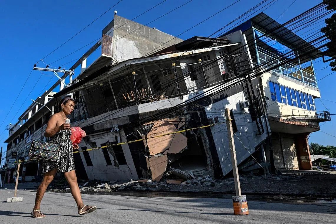
The June 8 earthquake that struck the southern Philippines with a magnitude of 7.8 has left an indelible mark on the landscape—literally reshaping the geography of Mindanao's coastline in ways that residents never anticipated. The tectonic shift, originating from movements along the nearby Cotabato Trench, did far more than topple buildings and trigger landslides; it fundamentally transformed the relationship between land and sea across stretches of shore that families have known for generations. At least 76 people lost their lives in the disaster, but for survivors like Arsenio Butil Jr., a fisherman and pastor in Sarangani province's Glan, the most unsettling aspect has been witnessing the earth literally rise beneath the waves.
When the powerful quake struck, Butil Jr. found himself watching in real time as the familiar shoreline underwent a dramatic transformation. The phenomenon, known to geologists as coastal uplift, pushed swathes of previously submerged coral above the waterline, creating walls of jagged, now-dead rock stretching for kilometres in both directions. What had always been the edge of the shore suddenly extended outward, leaving fishing boats that once floated at the water's edge stranded on the wrong side of newly exposed seabed. The visual shock of such rapid geological change unsettled not only Butil Jr. but entire communities whose livelihoods and sense of place depended on the stability of their coastlines.
According to Nane Danlag, a specialist at the Philippines' seismology centre in General Santos City, the seabed rose approximately two metres during the earthquake, extending the shore by roughly 200 metres in some areas. The affected zone stretched across nearly 100 kilometres, spanning between two towns and affecting entire provinces. While such uplift is geologically natural and part of long-term tectonic processes that have been unfolding for thousands of years, the speed and magnitude of this particular event created profound disruption. Danlag emphasised that the newly formed coastline represents a permanent change in the physical geography of the region, one that residents must now learn to navigate psychologically and practically.
The immediate aftermath of the earthquake revealed the psychological toll such radical environmental change inflicts on communities. When Butil Jr. experienced the initial tremor, he observed the sea receding and returning multiple times—perhaps three or four cycles—as the earth shifted beneath the ocean. Fish began dying and floating as the water receded, providing a stark visual reminder of the catastrophic forces at work. About 100 residents, including fishermen and their families from a neighbouring village, fled to higher ground and have remained in an encampment, unwilling to return to their destroyed homes. Datu Atom Malimpnig, a Maguindanaon chieftain, noted that the group's reluctance to descend from the hills reflects deeper anxieties about tsunami risk and further seismic activity rather than merely the physical destruction of their dwellings.
These anxieties are not unfounded, given the seismic context of the region. The Cotabato Trench, located as close as 50 kilometres off the coast of Mindanao, is a site of frequent and intense tectonic activity. In January, the trench generated thousands of mostly minor tremors—a seismic swarm that prompted concern among disaster risk reduction experts. A United Nations report released in mid-May suggested that such patterns could precede major earthquakes, lending credence to residents' fears that another powerful quake might follow. Since June 8, more than 8,500 aftershocks have continued to shake the region, keeping nerves on edge and reinforcing the hesitancy of displaced populations to commit to rebuilding.
The economic consequences of coastal uplift have proven severe for local businesses dependent on maritime access. At the Isla Jardin del Mar resort, a facility that marketed itself on the appeal of white sand beaches and pristine seaside experiences, the newly exposed coral has created an impassable barrier between the resort and the water. Resort staff member Edzel Baylon lamented that the shallow water now surrounding the shore has rendered it unsuitable for swimming and fundamentally undermined the resort's primary draw for customers. What was once an idyllic beachfront has become inaccessible, representing a significant economic loss for a tourism-dependent community already reeling from earthquake damage. The resort industry, like fishing, depends on predictable coastal geography, and the sudden alteration has disrupted business models that developed over years or decades.
For those contemplating reconstruction, the geological hazards remain daunting. Butil Jr. observed that the ground in Glan is now marked by long cracks, rendering the area dangerous for rebuilding efforts until seismic stability is restored. Residents fear that if an earthquake as powerful as the June 8 event were to strike again, structures built on fractured and unstable ground would likely collapse. This concern took on immediate relevance when, during an interview, a 5.4-magnitude aftershock shook the ground beneath residents' feet, serving as a visceral reminder that the seismic crisis has not concluded. The accumulation of aftershocks—over 8,500 since the initial event—suggests that the Cotabato Trench remains active and unstable, heightening uncertainty about when or whether it is safe to return to normal life.
The broader implications of this event extend beyond the immediate disaster zone and into discussions about preparedness across the Philippines and Southeast Asia more broadly. The region straddles multiple tectonic boundaries and remains among the world's most seismically active areas. The speed with which coastal uplift can occur, permanently altering geography and displacing populations, underscores the need for improved early warning systems, evacuation protocols, and post-disaster planning. Communities in the Philippines, Indonesia, and other Southeast Asian nations built along similar tectonic boundaries face comparable risks, yet preparedness levels remain uneven.
The human dimension of this geological upheaval has been particularly stark. Residents who have spent lifetimes learning the nuances of their coastlines—where to fish, how currents move, where safe passage lies—suddenly find their accumulated knowledge obsolete. The permanence of the change compounds this disorientation; this is not damage that can be repaired or restored but a fundamental alteration of the landscape itself. Malimpnig's observation that the sea has not remained the same reflects not merely a complaint about physical change but an expression of existential displacement. For fishing communities in particular, the new coastline means relearning where fish are likely to be found, which routes remain navigable, and how to operate in an environment that no longer matches their mental maps and accumulated experience.
Looking forward, the challenge facing Mindanao's affected communities is multifaceted: managing ongoing seismic risk while attempting to rebuild livelihoods and homes, adapting to a permanently altered coastline, and contending with psychological trauma from witnessing such dramatic environmental change. Government assistance has begun, with aid workers providing basic sustenance to evacuees, but longer-term recovery will require substantial resources and careful planning. The question of whether and when residents will feel confident enough to return to low-lying areas remains unresolved, particularly given the continued seismic activity and the knowledge that the Cotabato Trench could produce further major earthquakes. For now, the newly exposed seabed serves as a visible reminder of the immense power of tectonic forces and the vulnerability of human communities built along their edges.